
Análisis del desempeño de técnicas de aprendizaje automático para identificar vegetación acuática con bandas de Sentinel-2
DOI:
https://doi.org/10.25260/EA.23.33.3.0.1960Palabras clave:
segmentación, Sentinel-2, aprendizaje automático, humedales fluvialesResumen
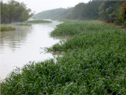
En la Argentina se observa una frecuencia creciente de desastres naturales como desbordes de ríos, sequías extremas e incendios forestales naturales. Ante estas catástrofes, es fundamental gestionar de manera eficiente la toma de decisiones rápidas para minimizar los daños; esta es una preocupación latente tanto de los gobiernos locales y regionales como de la comunidad científica. La cuenca del río Paraná, en la Argentina, representa un recurso estratégico, ya que engloba la mayor riqueza fluvial y ecológica, además de grandes centros urbanos. Sin embargo, los eventos extremos que caracterizan la dinámica de los humedales afectan a los centros urbanos ubicados en sus cercanías. La presencia de vegetación acuática (libre o arraigada) enmascara las áreas anegadas y ocultan los primeros indicios de anegamiento, lo cual dificulta el monitoreo y la rápida detección de esas áreas. En este trabajo se utilizaron imágenes satelitales ópticas y modelos de aprendizaje automático para clasificar las diferentes coberturas del suelo en humedales del sistema fluvial del Paraná. Se hizo foco en ambientes donde coexisten el agua libre y la vegetación acuático-palustre, típicos de la región metropolitana de la ciudad de Santa Fe, considerando las limitaciones técnicas de los organismos tomadores de decisiones. Se usaron imágenes de la misión Sentinel-2 (S2) para entrenar y evaluar el rendimiento de distintos algoritmos de aprendizaje automático. Se utilizaron todas las bandas de las imágenes S2, unificando la resolución espacial en 10 m. Los resultados indicaron que las bandas de aerosoles costeros (B1) y dos bandas de infrarrojo medio (B11 y B12) son las que aportan más información para identificar las clases muestreadas. Por otra parte, el método random forest fue el de mejor desempeño para la clase vegetación acuática, de interés especial en este trabajo.
Citas
Akbari, V., M. Simpson, S. Maharaj, A. Marino, D. Bhowmik, G. Prabhu, et al. 2021. Monitoring aquatic weeds in Indian wetlands using multitemporal remote sensing data with machine learning techniques. Pp. 6847-6850 en 2021 IEEE International Geoscience and Remote Sensing Symposium IGARSS. https://doi.org/10.1109/IGARSS47720.2021.9553207.
Ashworth, P. J., and J. Lewin. 2012. How do big rivers come to be different? Earth-Science Reviews 114(1-2):84-107. https://doi.org/10.1016/j.earscirev.2012.05.003.
Ball, J. E., D. T. Anderson, and C. S. Chan. 2017. Comprehensive survey of deep learning in remote sensing: theories, tools, and challenges for the community. Journal of Applied Remote Sensing 11(4):042609-042609. https://doi.org/10.1117/1.JRS.11.042609.
Berhane, T. M., C. R. Lane, Q. Wu, B. C. Autrey, O. A. Anenkhonov, V. V. Chepinoga, and H. Liu. 2018. Decision-tree, rule-based, and random forest classification of high-resolution multispectral imagery for wetland mapping and inventory. Remote Sensing 10(4):580. https://doi.org/10.3390/rs10040580.
Breiman, L. 2001. Random forests. Machine Learning 45(1):5-32. https://doi.org/10.1023/A:1010933404324.
Carignan, R., and J. J. Neiff. 1992. Nutrient dynamics in the floodplain ponds of the Paraná River (Argentina) dominated by the water hyacinth Eichhornia crassipes. Biogeochemistry 17(2):85-121. https://doi.org/10.1007/BF00002642.
Ceirano, E., C. Paoli, and M. Schreider. 2000. Las inundaciones en el área de Santa Fe. Interpretación de sus efectos y simulación de los subsistemas Leyes-Setúbal y Ruta Nacional 168-Alto Verde. Pp. 239-297 en C. Paoli C. and M. Schreider (eds.). El Río Paraná en su Tramo Medio. Una contribución al conocimiento y prácticas ingenieriles en un gran río de llanura. Vol. 2. Universidad Nacional del Litoral: Santa Fe.
Chuvieco, E. 1991. Fundamentos de teledetección espacial. Estudios Geográficos 52(203):371.
Cortes, C., and V. Vapnik. 1995. Support-vector networks. Machine Learning 20(3):273-297. https://doi.org/10.1007/BF00994018.
de Grandpré, A., C. Kinnard, and A. Bertolo. 2022. Open-Source Analysis of Submerged Aquatic Vegetation Cover in Complex Waters Using High-Resolution Satellite Remote Sensing: An Adaptable Framework. Remote Sensing 14(2):267. https://doi.org/10.3390/rs14020267.
Dronova, I., P. Gong, N. E. Clinton, L. Wang, W. Fu, S. Qi, and Y. Liu. 2012. Landscape analysis of wetland plant functional types: The effects of image segmentation scale, vegetation classes and classification methods. Remote Sensing of Environment 127:357-369. https://doi.org/10.1007/s11356-022-20386-9.
García, G., V. Venturini, M. Brogioni, F. Walker, and L. Rodríguez. 2019. Soil moisture estimation over flat lands in Argentinean Pampas region using Sentinel-1A data and non-parametric methods. International Journal of remote sensing 40(10):3689-3720. https://doi.org/10.1080/01431161.2018.1552813.
Giacosa, R., C. Paoli, and P. Cacik. 2000. Conocimiento del régimen hidrológico. Pp. 71-103 en C. Paoli and M. Schreider (eds.). El Río Paraná en su Tramo Medio. Una contribución al conocimiento y prácticas ingenieriles en un gran río de llanura. Vol. 2. Universidad Nacional del Litoral: Santa Fe.
Drusch, M., U. Del Bello, S. Carlier, O. Colin, V. Fernández, F. Gascón, B. Hoersch, C. Isola, et al. 2012. Sentinel-2: ESA's optical high-resolution mission for GMES operational services. Remote Sensing of Environment 120:25-36. https://doi.org/10.1016/j.rse.2011.11.026.
Ferral, A., E. Luccini, A. Aleksinkó, and C. M. Scavuzzo. 2019. Flooded-area satellite monitoring within a Ramsar wetland Nature Reserve in Argentina. Remote Sensing Applications: Society and Environment 15:100230. https://doi.org/10.1016/j.rsase.2019.04.003.
Guo, M., J. Li, C. Sheng, J. Xu, and L. Wu. 2017. A review of wetland remote sensing. Sensors 17(4):777. https://doi.org/10.3390/s17040777.
Hunter, P., D. Gilvear, A. Tyler, N. Willby, A. and Kelly. 2010. Mapping macrophytic vegetation in shallow lakes using the Compact Airborne Spectrographic Imager (CASI). Aquatic Conservation: Marine and Freshwater Ecosystems 20(7):717-727. https://doi.org/10.1002/aqc.1144.
Husson, E., F. Ecke, H. and Reese. 2016. Comparison of manual mapping and automated object-based image analysis of non-submerged aquatic vegetation from very-high-resolution UAS images. Remote Sensing 8(9):724. https://doi.org/10.1007/s12665-013-2628-0.
Hwang, J. W., and H. S. Lee. 2004. Adaptive image interpolation based on local gradient features. IEEE Signal Processing Letters 11(3):359-362. https://doi.org/10.1109/LSP.2003.821718.
Kandus, P., H. Karszenbaum, and L. Frulla. 1999. Land cover classification system for the Lower Delta of the Paraná River (Argentina): Its relationship with Landsat Thematic Mapper spectral classes. Journal of Coastal Research 909-926. URL: jstor.org/stable/4299011.
Kandus, P., P. G. Minotti, N. S. Morandeira, R. Grimson, G. González Trilla, E. B. González, et al. 2018. Remote sensing of wetlands in South America: status and challenges. International Journal of Remote Sensing 39(4):993-1016. https://doi.org/10.1080/01431161.2017.1395971.
Klemas, V. 2013. Remote sensing of emergent and submerged wetlands: an overview. Int J Remote Sens 34:6286-6320. https://doi.org/10.1080/01431161.2013.800656.
Krishnaraj, A., and R. Honnasiddaiah. 2022. Remote sensing and machine learning based framework for the assessment of spatio-temporal water quality in the Middle Ganga Basin. Environmental Science and Pollution Research 1-20. https://doi.org/10.1007/s11356-022-20386-9.
Lang, M. W., and G. W. McCarty. 2008. Remote sensing data for regional wetland mapping in the United States: trends and future prospects. Pp. 73-112 en R. E. Russo (ed.). Wetlands: Ecology, Conservation and Restoration. Nova Science Publishers, Inc., Hauppauge, New York.
Latrubesse, E. M. 2008. Patterns of anabranching channels: the ultimate end-member adjustment of mega rivers. Geomorphology 101(1–2):130-145. https://doi.org/10.1016/j.geomorph.2008.05.035.
Li, C., L. Zhou, and W. Xu. 2021. Estimating aboveground biomass using Sentinel-2 MSI data and ensemble algorithms for grassland in the Shengjin Lake Wetland, China. Remote Sensing 13(8):1595. https://doi.org/10.3390/rs13081595.
Li, Z., H. Chen, J. C. White, M. A. Wulder, and T. Hermosilla. 2020. Discriminating treed and non-treed wetlands in boreal ecosystems using time series Sentinel-1 data. International Journal of Applied Earth Observation and Geoinformation 85:102007. https://doi.org/10.1016/j.jag.2019.102007.
López, F. J. A., J. R. Avi, and M. V. A. Fernández. 2018. Control estricto de matrices de confusión por medio de distribuciones multinomiales. Geofocus: Revista Internacional de Ciencia y Tecnología de la Información Geográfica (21):6. https://doi.org/10.21138/GF.591.
Mahdavi, S., B. Salehi, J. Granger, M. Amani, B. Brisco, and W. Huang. 2018. Remote sensing for wetland classification: A comprehensive review. GIScience and Remote Sensing 55(5):623-658. https://doi.org/10.1080/15481603.2017.1419602.
Mahdianpari, M., B. Salehi, F. Mohammadimanesh, and B. Brisco. 2017. An assessment of simulated compact polarimetric SAR data for wetland classification using random forest algorithm. Canadian Journal of Remote Sensing 43(5):468-484. https://doi.org/10.1080/07038992.2017.1381550.
Marchetti, Z. Y., M. S. Pereira, C. G. Ramonell, and E. M. Latrubesse. 2013. Vegetation and its relationship with geomorphologic units in the Paraná River floodplain, Argentina. Journal of South American Earth Sciences 46:122-136. https://doi.org/10.1016/j.jsames.2013.03.010.
Marchetti, Z. Y., and C. G. Ramonell. 2014. Valoración preliminar de la retención de sedimentos por Hidrófitas en Cauces secundarios del Río Paraná Medio. Aqua-LAC 6(1):8-16. https://doi.org/10.29104/phi-aqualac/2014-v6-1-02.
Marchetti, Z. Y., P. G. Minotti, C. G. Ramonell, F. Schivo, and P. Kandus. 2016. NDVI patterns as indicator of morphodynamic activity in the middle Paraná River floodplain. Geomorphology 253:146-158. https://doi.org/10.1016/j.geomorph.2015.10.003.
Millard, K., and M. Richardson. 2015. On the importance of training data sample selection in random forest image classification: A case study in peatland ecosystem mapping. Remote Sensing 7(7):8489-8515. https://doi.org/10.3390/rs70708489.
Mirmazloumi, S. M., A. Moghimi, B. Ranjgar, F. Mohseni, A. Ghorbanian, S. A. Ahmadi, et al. 2021. Status and trends of wetland studies in Canada using remote sensing technology with a focus on wetland classification: a bibliographic analysis. Remote Sensing 13(20):4025. https://doi.org/10.3390/rs13204025.
Munizaga, J., M. García, F. Ureta, V. Novoa, O. Rojas, and C. Rojas. 2022. Mapping Coastal Wetlands Using Satellite Imagery and Machine Learning in a Highly Urbanized Landscape. Sustainability 14(9):5700. https://doi.org/10.3390/su14095700.
National Wetlands Working Group. 1997. The Canadian Wetland Classification System. National Wetlands Working Group, Waterloo, ON, Canada. URL: library.wur.nl/WebQuery/clc/1783071.
Ozesmi, S. L., and M. E. Bauer. 2002. Satellite remote sensing of wetlands. Wetlands Ecology and Management 10:381-402. https://doi.org/10.1023/A:1020908432489.
Pal, M. 2005. Random forest classifier for remote sensing classification. International journal of remote Sensing 26(1):217-222. https://doi.org/10.1080/01431160412331269698.
Pande-Chhetri, R., A. Abd-Elrahman, and C. Jacoby. 2014. Classification of submerged aquatic vegetation in black river using hyperspectral image analysis. Geomatica 68(3):169-182. https://doi.org/10.5623/cig2014-302.
Pereira, O. J. R., A. J. Melfi, and C. R. Montes. 2017. Image fusion of Sentinel-2 and CBERS-4 satellites for mapping soil cover in the Wetlands of Pantanal. International Journal of Image and Data Fusion 8(2):148-172. https://doi.org/10.1080/19479832.2016.1261946.
Piaser, E., P. and Villa. 2022. Comparing machine learning techniques for aquatic vegetation classification using Sentinel-2 data. pp. 465-470 en 2022 IEEE 21st Mediterranean Electrotechnical Conference (MELECON). IEEE. https://doi.org/10.1109/MELECON53508.2022.9843103.
Poursanidis, D., D. Traganos, P. Reinartz, and N. Chrysoulakis. 2019. On the use of Sentinel-2 for coastal habitat mapping and satellite-derived bathymetry estimation using downscaled coastal aerosol band. International Journal of Applied Earth Observation and Geoinformation 80:58-70. https://doi.org/10.1016/j.jag.2019.03.012.
Sánchez-Espinosa, A., and C. Schröder. 2019. Land use and land cover mapping in wetlands one step closer to the ground: Sentinel-2 versus Landsat 8. Journal of Environmental Management 247:484-498. https://doi.org/10.1016/j.jenvman.2019.06.084.
Singh, S. K., P. K. Srivastava, M. Gupta, J. K. Thakur, and S. Mukherjee. 2014. Appraisal of land use/land cover of mangrove forest ecosystem using support vector machine. Environmental Earth Sciences 71(5):2245-2255. https://doi.org/10.1007/s12665-013-2628-0.
Slagter, B., N. E. Tsendbazar, A. Vollrath, and J. Reiche. 2020. Mapping wetland characteristics using temporally dense Sentinel-1 and Sentinel-2 data: A case study in the St. Lucia wetlands, South Africa. International Journal of Applied Earth Observation and Geoinformation 86:102009. https://doi.org/10.1016/j.jag.2019.102009.
Tang, H., Z. Dai, Y. Jiang, T. Li, and C. Liu. 2018. PCG classification using multidomain features and SVM classifier. BioMed Research International 2018. https://doi.org/10.1155/2018/4205027.
Tiner, R. W., M. W. Lang, and V. V. Klemas. 2015. Remote sensing of wetlands: applications and advances. CRC press, Taylor and Francis Group. https://doi.org/10.1201/b18210.
Traganos, D., and P. Reinartz. 2018. Mapping Mediterranean seagrasses with Sentinel-2 imagery. Marine Pollution Bulletin 134:197-209. https://doi.org/10.1016/j.marpolbul.2017.06.075.
Traganos, D., B. Aggarwal, D. Poursanidis, K. Topouzelis, N. Chrysoulakis, and P. Reinartz. 2018. Towards global-scale seagrass mapping and monitoring using Sentinel-2 on Google Earth Engine: The case study of the aegean and ionian seas. Remote Sensing 10(8):1227. https://doi.org/10.3390/rs10081227.
Vanderhoof, M. K., T. J. Hawbaker, C. Teske, A. Ku, J. Noble, and J. Picotte. 2021. Mapping wetland burned area from Sentinel-2 across the Southeastern United States and its contributions relative to Landsat-8 (2016–2019). Fire 4(3):52. https://doi.org/10.3390/fire4030052.
Vapnik, V., I. Guyon, and T. Hastie. 1995. Support vector machines. Machine Learning 20(3):273-297. https://doi.org/10.1007/BF00994018.
Walker, E., D. C: Fonnegra Mora, and V. Venturini. 2021. Monitoreo de excesos hídricos en Santa Fe mediante la plataforma Google Earth Engine. RPIC 2021. XIX Edición de la XIX Reunión de Trabajo en Procesamiento de la Información y Control. San Juan- Argentina. 3-5 noviembre 2021.
Whyte, A., K. P. Ferentinos, and G. P. Petropoulos. 2018. A new synergistic approach for monitoring wetlands using Sentinels-1 and 2 data with object-based machine learning algorithms. Environmental Modelling and Software 104:40-54. https://doi.org/10.1016/j.envsoft.2018.01.023.
Descargas
Publicado
Cómo citar
Número
Sección
Licencia
Derechos de autor 2023 Virginia Venturini; Zuleica Y. Marchetti; Gianfranco Fagioli, Elisabet Walker

Esta obra está bajo una licencia Creative Commons Reconocimiento 3.0 Unported.
Las/os autoras/es conservan sus derechos de autoras/es: 1) cediendo a la revista el derecho a su primera publicación, y 2) registrando el artículo publicado con una Licencia de Atribución de Creative Commons (CC-BY 4.0), lo que permite a autoras/es y terceros verlo y utilizarlo siempre que mencionen claramente su origen (cita o referencia incluyendo autoría y primera publicación en esta revista). Las/os autores/as pueden hacer otros acuerdos de distribución no exclusiva siempre que indiquen con claridad su origen, así como compartir y divulgar ampliamente la versión publicada de su trabajo.

