
La iniciativa MapBiomas Uruguay para monitorear los cambios anuales en el uso y cobertura del suelo entre 1985 y 2023
DOI:
https://doi.org/10.25260/EA.26.36.1.0.2568Palabras clave:
Landsat, datos de acceso abierto, pastizales del Río de la Plata, transiciones, sensores remotosResumen
1. El cambio en el uso y la cobertura del suelo ha sido identificado como uno de los impulsores más significativos del sistema terrestre. En este contexto, es fundamental producir mapas precisos, detallados y de largo plazo.
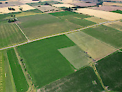
2. Aquí presentamos la Colección 2 de MapBiomas Uruguay, que proporciona mapas anuales del uso y la cobertura del suelo para el país, desde 1985 hasta 2023. Los mapas se generaron utilizando imágenes Landsat (30 m) y un enfoque de clasificación supervisada basado en el algoritmo Random Forest. Se mapearon y validaron ocho clases de uso y cobertura del suelo: Vegetación leñosa nativa, Plantaciones forestales, Áreas pantanosas / vegetación inundada, Pastizales, Pasturas sembradas, Cultivos anuales, Áreas no vegetadas y Cuerpos de agua.
3. Observamos una disminución sustancial de los pastizales naturales (-21.4%), reemplazados, sobre todo, por cultivos anuales (+77.4%) y plantaciones forestales (+857%).
4. Las plantaciones forestales se expandieron principalmente en las regiones este, noreste y centro-oeste; los cultivos anuales aumentaron sobre todo en la región centro-sur. La región centro-norte conserva la mayor proporción de pastizales naturales del país.
5. La precisión general de los mapas superó el 80% para los años analizados.
6. Implicancias. Estos mapas representan un paso importante en la cartografía y seguimiento de los cambios en el uso y la cobertura del suelo en los pastizales templados y subtropicales de Uruguay, ofreciendo una combinación sin precedentes de resolución espacial y temporal. Nuestra plataforma, que brinda acceso a mapas y estadísticas anuales, está disponible públicamente en línea para consulta y descarga. Esta herramienta de acceso abierto constituye un recurso valioso para la planificación territorial, la regulación del uso del suelo y la formulación de políticas públicas que apoyen la sostenibilidad de los sistemas productivos.
Citas
Altesor, A., G. Eguren, N. Mazzeo, D. Panario, and C. Rodríguez. 2008. La industria de la celulosa y sus efectos: certezas e incertidumbres. Ecología Austral 18:291-303. URL: tinyurl.com/4pw8mm7c.
Alvarez Gebelin, A., M. Borretti, C. Cohn, and G Minutti. 2024. Land Cover and Land Use in Uruguay Using Land Cover Classification System Methodology. Land 13(12):2168. https://doi.org/10.3390/land13122168.
Baeza, S., and J. M. Paruelo. 2020. Land use/land cover change (2000-2014) in the Rio de la Plata 615 grasslands: an analysis based on MODIS NDVI time series. Remote Sensing 12(3):381. https://doi.org/10.3390/rs12030381.
Baeza, S., F. Gallego, F. Lezama, A. Altesor, and J. M. Paruelo. 2011. Cartografía de los pastizales naturales en las regiones geomorfológicas de Uruguay predominantemente ganaderas. Pp. 33-54 in A. Altesor, W. Ayala and J. M. Paruelo (eds.). Bases ecológicas y tecnológicas para el manejo de pastizales. Serie 26 FPTA, INIA. Montevideo, Uruguay.
Baeza, S., P. Baldassini, C. Bagnato, P. Pinto, and J. M. Paruelo. 2014. Caracterización del uso/cobertura del suelo en Uruguay a partir de series temporales de imágenes MODIS. Agrociencia (Uruguay) 18(2):95-105. https://doi.org/10.31285/AGRO.18.470.
Baeza, S., G. Rama, F. Lezama, A. Altesor, L. López-Mársico, and J. M. Paruelo. 2019. Cartografía de los pastizales naturales en las regiones geomorfológicas de Uruguay predominantemente ganaderas. Ampliación y actualización. Pp. 27-47 in A. Altesor, L. López-Mársico and J. M. Paruelo (eds.). Bases ecológicas y tecnológicas para el manejo de pastizales II. Serie FPTA 69, INIA. Montevideo, Uruguay.
Baeza, S., and J. M. Paruelo. 2020. Land use/land cover change (2000-2014) in the Rio de la Plata 615 grasslands: an analysis based on MODIS NDVI time series. Remote Sensing 12(3):381. https://doi.org/10.3390/rs12030381.
Baeza, S., E. Vélez-Martin, D. De Abelleyra, S. Banchero, F. Gallego, J. Schirmbeck, S. Verón, et al. 2022. Two decades of land cover mapping in the Río de la Plata grassland region: The MapBiomas Pampa initiative. Remote Sensing Applications: Society and Environment 28:100834. https://doi.org/10.1016/j.rsase.2022.100834.
Baldassini, P., G. Camba Sans, D. Alcaraz Segura, C. Conde, and J. M. Paruelo. 2024. Mapping cropping systems and their effects on ecosystem functioning and services in the Argentine Pampas. Agriculture, Ecosystems and Environment 369:109027. https://doi.org/10.1016/j.agee.2024.109027.
Baldi, G., and J. M. Paruelo. 2008. Land-Use and Land Cover Dynamics in South American Temperate Grasslands. Ecology and Society 13:6. https://doi.org/10.5751/ES-02481-130206.
Cabello, J., and J. M. Paruelo. 2008. La teledetección en estudios ecológicos. Ecosistemas 17(3). URL: tinyurl.com/4u787njd.
Camba Sans, G., P. Baldassini, F. Gallego, and J. M. Paruelo. 2024. Cropland functional diversity increases ecosystem services supply in watersheds of the Rio de la Plata Grasslands. Landscape Ecology 39(12):210. https://doi.org/10.1007/s10980-024-02011-x.
Campbell, B. M., D. J. Beare, E. M. Bennett, J. M. Hall-Spencer, J. S. Ingram, F. Jaramillo, R. Ortiz, et al. 2017. Agriculture production as a major driver of the Earth system exceeding planetary boundaries. Ecology and Society 22(4). https://doi.org/10.5751/ES-09595-220408.
Cano, D., C. Cacciuttolo, M. Custodio, and M. Nosetto. 2023. Effects of grassland afforestation on water yield in basins of Uruguay: A spatio-temporal analysis of historical trends using remote sensing and field measurements. Land 12(1):185. https://doi.org/10.3390/land12010185.
Ceballos, G., P. R. Ehrlich, A. D. Barnosky, A. García, R. M. Pringle, and T. M. Palmer. 2015. Accelerated modern human-induced species losses: Entering the sixth mass extinction. Science Advances 1(5):e1400253. https://doi.org/10.1126/sciadv.1400253.
Chaves, M., M. Picoli, and I. Sanches. 2020. Recent applications of Landsat 8/OLI and Sentinel-2/MSI for land use and land cover mapping: A systematic review. Remote Sensing 12(18):3062. https://doi.org/10.3390/rs12183062.
Congalton, R. G. 1991. A review of assessing the accuracy of classifications of remotely sensed data. Remote Sensing of the Environment 37:35-46. https://doi.org/10.1016/0034-4257(91)90048-B.
Congalton, R. G. 2004. Putting the map back in map accuracy assessment. Pp. 1-11 in R. S. Lunetta and J. G. Lyon (eds.). Remote Sensing and GIS Accuracy Assessment. CRS Press, Florida, USA. https://doi.org/10.1201/9780203497586.ch1.
Curran, P. J. 1985. Principles of remote sensing. Longman Inc. New York, USA. https://doi.org/10.1080/01431168508948322.
DIEA-MGAP. 2025. Dirección de Estadísticas Agropecuarias. Ministerio de Ganadería Agricultura y Pesca. Uruguay. URL: tinyurl.com/3xvnaen5.
Di Gregorio, A., and L. J. M. Jansen. 1998. Environment and Natural Resources Service, GCP/RAF/287/ITA Africover - East Africa Project and Soil Resources, Management and Conservation Service. FAO, Rome.
DGRN-MGAP. 2021. Mapa del uso y cobertura del suelo del Uruguay para el año 2020/2021. Dirección General de Recursos Naturales. ministerio de Ganadería, Agricultura y Pesca. Uruguay. URL: tinyurl.com/4846z83c.
DINOT-MVOT. 2022. Mapas de la cobertura del suelo. Dirección Nacional de Ordenamiento Territorial. Ministerio de Vivienda y Ordenamiento Territorial. URL: tinyurl.com/38ms7b9d.
Ellis, E. C., J. O. Kaplan, D. Q. Fuller, S. Vavrus, K. Klein Goldewijk, and P. H. Verburg 2013. Used planet: A global history. Proceedings of the National Academy of Sciences 110(20):7978-7985. https://doi.org/10.1073/pnas.1217241110.
Eva, H. D., A. S. Belward, E. E. De Miranda, C. M. Di Bella, V. Gond, O. Huber, S. Jones, M. Sgrenzaroli, and S. Fritz. 2004. A land cover map of South America. Global Change Biology 10(5):731-744. https://doi.org/10.1111/j.1529-8817.2003.00774.x.
FAOSTAT. 2025. Statistics Division of the Food and Agriculture Organization of the United Nations. Rome, Italy. URL: fao.org/faostat/en.
Farley, K. A., E. G. Jobbágy, and R. B. Jackson. 2005. Effects of afforestation on water yield: a global synthesis with implications for policy. Global Change Biology 11(10):1565-1576. https://doi.org/10.1111/j.1365-2486.2005.01011.x.
Foley, J. A., R. DeFries, G. P. Asner, C. Barford, G. Bonan, S. R. Carpenter, F. S. Chapin, M. T. Coe, G. C. Daily, et al. 2005. Global consequences of land use. Science 309:570-574. https://doi.org/10.2489/jswc.67.2.37A.
Friedl, M. A., D. Sulla-Menashe, B. Tan, A. Schneider, N. Ramankutty, A. Sibley, and X. Huang. 2010. MODIS Collection 5 global land cover: Algorithm refinements and characterization of new datasets. Remote Sensing of Environment 114(1):168-182. https://doi.org/10.1016/j.rse.2009.08.016.
Gallant, A. L. 2015. The Challenges of Remote Monitoring of Wetlands. Remote Sensing 7(8):10938-10950. https://doi.org/10.3390/rs70810938.
Gallego, F., and J. M. Paruelo. 2025. Projected Land‐Cover Changes and Their Consequences on the Supply of Ecosystem Services in Uruguay. Austral Ecology 50(8):e70111. https://doi.org/10.1111/aec.70111.
Gitelson, A. A., Y. J. Kaufman, and M. N. Merzlyak. 1996. Use of a green channel in remote sensing of global vegetation from EOS-MODIS. Remote Sensing of Environment 58(3):289-298. https://doi.org/10.1016/S0034-4257(96)00072-7.
Goodwin, N. R., L. J. Collett, R. J. Denham, N. Flood, and D. Tindall. 2013. Cloud and cloud shadow screening across Queensland, Australia: An automated method for Landsat TM/ETM+ time series. Remote Sensing of Environment 134:50-65. https://doi.org/10.1016/j.rse.2013.02.019.
Gorelick, N., M. Hancher, M. Dixon, S. Ilyushchenko, D. Thau, and R. Moore. 2017. Google Earth Engine: Planetary-scale geospatial analysis for everyone. Remote Sensing of Environment 202:18-27. https://doi.org/10.1016/j.rse.2017.06.031.
Gorosábel, A., L. Estigarribia, L. F. Lopes, A. M. Martinez, J. A. Martínez-Lanfranco, A. A. Adenle, C. Rivera-Rebella, and M. A. Oyinlola. 2020. Insights for policy-based conservation strategies for the Río de la Plata Grasslands through the IPBES framework. Biota Neotropica 20. https://doi.org/10.1590/1676-0611-BN-2019-0902.
Graesser, J., N. Ramankutty, and O. T. Coomes. 2018. Increasing expansion of large-scale crop production onto deforested land in sub-Andean South America. Environmental Research Letters 13(8):084021. https://doi.org/10.1088/1748-9326/aad5bf.
Graesser, J., R. Stanimirova, K. Tarrio, E. J. Copati, J. N. Volante, S. R. Verón, S. Banchero, H. Elena, D. Abelleyra, and M. A. Friedl. 2022. Temporally-consistent annual land cover from Landsat time series in the Southern Cone of South America. Remote Sensing 14(16):4005. https://doi.org/10.3390/rs14164005.
Gutiérrez, F., F. Gallego, J. M. Paruelo, and C. Rodríguez. 2020. Damping and lag effects of precipitation variability across trophic levels in Uruguayan rangelands. Agricultural Systems 185:102956. https://doi.org/10.1016/j.agsy.2020.102956.
Hardisky, M. A., V. Klemas, and R. M. Smart. 1983. The influence of soil salinity, growth form, and leaf moisture on the spectral radiance of Spartina alterniflora canopies. Photogrammetric Engineering Remote Sensing 48:77-83. URL: tinyurl.com/y9cwnx3n.
Hasan, S. S., L. Zhen, M. G. Miah, T. Ahamed, and A. Samie. 2020. Impact of land use change on ecosystem services: A review. Environmental Development 34:100527. https://doi.org/10.1016/j.envdev.2020.100527.
Henderson, F. M., and A. J. Lewis. 2008. Radar detection of wetland ecosystems: a review. International Journal of Remote Sensing 29(20):5809-5835. https://doi.org/10.1080/01431160801958405.
INUMET. 2025. Estadísticas climatológicas para el período 1991-2020. Instituto Uruguayo de Meteorología. Uruguay. URL: tinyurl.com/4yd6rkw8.
IPBES. 2019: Summary for policymakers of the global assessment report on biodiversity and ecosystem services of the Intergovernmental Science-Policy Platform on Biodiversity and Ecosystem Services. S. Díaz, J. Settele, E. S. Brondízio, H. T. Ngo, et al. (eds.). IPBES secretariat, Bonn, Germany. URL: tinyurl.com/yducnvcc.
Jaureguiberry, P., N. Titeux, M. Wiemers, D. E. Bowler, L. Coscieme, A. S. Golden, C. A. Guerra, et al. 2022. The direct drivers of recent global anthropogenic biodiversity loss. Science Advances 8(45):eabm9982. https://doi.org/10.1126/sciadv.abm9982.
Jobbágy, E. G., M. Vasallo, K. A. Farley, G. Piñeiro, M. F. Garbulsky, M. D. Nosetto, R. B. Jackson, and J. M. Paruelo. 2006. Forestación en pastizales: hacia una visión integral de sus oportunidades y costos ecológicos. Agrociencia (Uruguay) 10(2):109-124. https://doi.org/10.31285/AGRO.10.934.
Keck, F., T. Peller, R. Alther, C. Barouillet, R. Blackman, E. Capo, T. Chonova, M. Couton, L. Fehlinger, et al. 2025. The global human impact on biodiversity. Nature 641:395-400. https://doi.org/10.1038/s41586-025-08752-2.
Key, C. H., and N. C. Benson. 1999. Measuring and remote sensing of burn severity. In Proceedings joint fire science conference and workshop (Vol. 2, p. 284). University of Idaho and International Association of Wildland Fire Moscow.
Lambin, E. F., and H. J. Geist. 2008. Land-use and land-cover change: local processes and global impacts. Springer Berlin, Heidelberg. https://doi.org/10.1007/3-540-32202-7.
Lezama, F., M. Pereira, A. Altesor, and J. M. Paruelo. 2019. Grasslands of Uruguay: classification based on vegetation plots. Phytocoenologia 49(3). https://doi.org/10.1127/phyto/2019/0215.
Luo, H., J. Quaas, and Y. Han. 2024. Decreased cloud cover partially offsets the cooling effects of surface albedo change due to deforestation. Nature Communication 15:7345. https://doi.org/10.1038/s41467-024-51783-y.
Modernel, P., W. A. Rossing, M. Corbeels, S. Dogliotti, V. Picasso, and P. Tittonell. 2016. Land use change and ecosystem service provision in Pampas and Campos grasslands of southern South America. Environmental Research Letters 11(11):113002. https://doi.org/10.1088/1748-9326/11/11/113002.
Nery, T., R. Sadler, M. Solis Aulestia, B. White, and M. Polyakov. 2019. Discriminating native and plantation forests in a Landsat time-series for land use policy design. International Journal of Remote Sensing 40(11):4059-4082. https://doi.org/10.1080/01431161.2018.1558375.
Newbold, T., L. N. Hudson, S. L. Hill, S. Contu, I. Lysenko, R. A. Senior, L. Börger, D. J. Bennett, et al. 2015. Global effects of land use on local terrestrial biodiversity. Nature 520(7545):45-50. https://doi.org/10.1038/nature14324.
OAN. 2022. Mapas de usos y coberturas del suelo 2022. Observatorio Ambiental Nacional. Ministerio de Ambiente. URL: tinyurl.com/ypmpwxka.
O’Connor, B., K. Moul, B. Pollini, W. X. de Lamo, and W. Simonson. 2020. Earth Observation for SDG: Compendium of Earth Observation contributions to the SDG Targets and Indicators. ESA: Harwell, UK. URL: tinyurl.com/4r2zhx9w.
Olofsson, P., G. M. Foody, M. Herold, S. V. Stehman, C. E. Woodcock, and M. A. Wulder. 2014. Good practices for estimating area and assessing accuracy of land change. Remote sensing of Environment 148:42-57. https://doi.org/10.1016/j.rse.2014.02.015.
OPYPA. 2021. Anuario de la Oficina de Programación y Política Agropecuaria (OPYPA) 2021. Ministerio de Ganadería, Agricultura y Pesca. Montevideo, Uruguay. URL: tinyurl.com/32p6f4j9.
Oyarzabal, M., B. Andrade, V. D. Pillar, and J. M. Paruelo. 2020. Temperate subhumid grasslands of southern South America. Pp. 1-17 in D. Di Paolo (ed.). Encyclopedia of the World's Biomes. Elsevier, Países Bajos. https://doi.org/10.1016/B978-0-12-409548-9.12132-3.
Oyhantcabal, W. 2005. The Clean Development Mechanism in Uruguay: towards a new relation between livestock and forestry. UNASYLVA-FAO. 56:19. URL: fao.org/3/a0413E/a0413E04.pdf.
Panario, D., O. Gutiérrez, L. Sánchez Bettucci, E. Peel, P. Oyhantcabal, and J. Rabassa. 2014. Ancient landscapes of Uruguay. Pp. 161-199 in J. Rabassa and C. Ollier (eds.). Gondwana landscapes in southern South America. Springer, Dordrecht. https://doi.org/10.1007/978-94-007-7702-6_8.
Paruelo, J. M., J. P. Guerschman, G. Piñeiro, E. G. Jobbágy, S. R. Verón, G. Baldi, and S. Baeza. 2006. Conceptual frameworks for the analysis of land use changes in Argentina and Uruguay. URL: tinyurl.com/4mz3nw32.
Paruelo, J. M. 2008. La caracterización funcional de ecosistemas mediante sensores remotos. Ecosistemas 17(3). URL: tinyurl.com/4jtem8dc.
Paruelo, J. M., M. Oesterheld, A. Altesor, G. Piñeiro, C. Rodríguez, P. Baldassini, G. Irisarri, L. López-Mársico, and V. D. Pillar. 2022. Grazers and fires: Their role in shaping the structure and functioning of the Río de la Plata Grasslands. Ecología Austral 32(2):784-805. https://doi.org/10.25260/EA.22.32.2.1.1880.
Paruelo, J. M., and M. Sierra. 2023. Sustainable intensification and ecosystem services: how to connect them in agricultural systems of southern South America. Journal of Environmental Studies and Sciences 13(1):198-206. https://doi.org/10.1007/s13412-022-00791-9.
Paruelo, J. M., G. Camba Sans, F. Gallego, P. Baldassini, L. Staiano, S. Baeza, and H. Dieguez. 2024. A comprehensive analysis of the environmental performance of the uruguayan agricultural sector. Ecological Indicators 166:112385. https://doi.org/10.1016/j.ecolind.2024.112385.
Pielke, R. A., G. Marland, R. A. Betts, T. N. Chase, J. L. Eastman, J. O. Niles, D. S. Niyogi, and S. W. Running. 2002. The influence of land-use change and landscape dynamics on the climate system: relevance to climate-change policy beyond the radiative effect of greenhouse gases. Philosophical Transactions of the Royal Society of London. Series A: Mathematical, Physical and Engineering Sciences 360(1797):1705-1719. https://doi.org/10.1098/rsta.2002.1027.
Pielke, R. A. 2005. Land use and climate change. Science 310(5754):1625-1626. https://doi.org/10.1126/science.1120529.
Ramankutty, N., and J. A. Foley. 1999. Estimating historical changes in global land cover: Croplands from 1700 to 1992. Global Biogeochemical Cycles 13(4):997-1027. https://doi.org/10.1029/1999GB900046.
Redo, D. J., T. M. Aide, M. L. Clark, and M. J. Andrade-Núñez. 2012. Impacts of internal and external policies on land change in Uruguay, 2001-2009. Environmental Conservation 39(2):122-131. https://doi.org/10.1017/S0376892911000658.
Richardson, J., W. Steffen, W. Lucht, J. Bendtsen, S. E. Cornell, J. F. Donges, M. Drüke, I. Fetzer, G. Bala, et al. 2023. Earth beyond six of nine Planetary Boundaries. Science Advances 9:37. https://doi.org/10.1126/sciadv.adh2458.
Roy, D. P., V. Kovalskyy, H. K. Zhang, E. F. Vermote, L. Yan, S. S. Kumar, and A. Egorov. 2016. Characterization of Landsat-7 to Landsat-8 reflective wavelength and normalized difference vegetation index continuity. Remote Sensing of Environment 185:57-70. https://doi.org/10.1016/j.rse.2015.12.024.
Rufin, P., P. Meyfroidt, F. O. Akinyemi, L. Estes, E. S. Ibrahim, M. Jain, H. Kerner, S. N. Lisboa, D. Lobell, et al. 2025. To enhance sustainable development goal research, open up commercial satellite image archives. Proceedings of the National Academy of Sciences 122(7):e2410246122. https://doi.org/10.1073/pnas.2410246122.
Running, S. W. 1990. Modified integrated NDVI for improving estimates of terrestrial net primary production. Pp. 15-24 in Remote Sensing of the Biosphere. Technical Symposium on Optics, Electro-Optics, and Sensors. https://doi.org/10.1117/12.21386.
Shao, G., and J. Wu. 2008. On the accuracy of landscape pattern analysis using remote sensing data. Landscape Ecology 23:505-511. https://doi.org/10.1007/s10980-008-9215-x.
Silveira, L., J. Alonso, and L. Martínez. 2006. Efecto de las plantaciones forestales sobre el recurso agua en el Uruguay. Agrociencia (Uruguay) 10(2):75-93. https://doi.org/10.31285/AGRO.10.931.
Silveira, L., and J. Alonso. 2009. Runoff modifications due to the conversion of natural grasslands to forests in a large basin in Uruguay. Hydrological Processes 23(2):320-329. https://doi.org/10.1002/hyp.7156.
Silveira, L., C. Chreties, J. Alonso, C. Amorín, P. De Izaguirre, M. Crisci, S. Symonds, L. Martínez, M. García, et al. 2011. Efectos de la actividad forestal sobre los recursos suelos y aguas. Serie 26 FPTA, INIA, Montevideo, Uruguay.
Silveira, L., P. Gamazo, J. Alonso, and L. Martínez. 2016. Effects of afforestation on groundwater recharge and water budgets in the western region of Uruguay. Hydrological Processes 30:3596-3608. https://doi.org/10.1002/hyp.10952.
SNIG-MGAP, 2023. Sistema Nacional de Información Ganadera. Declaración Jurada de Existencias DICOSE 2023. URL: tinyurl.com/d8us9nsm.
Soriano, A., R. J. C. León, E. O. Sala 1991. Río de la Plata Grasslands. Pp. 367-407 in R. Coupland (ed.). Ecosystems of the world. Natural grasslands: Introduction and Western Hemisphere, 1st ed. Elsevier, New York.
Souza Jr., C. M., J. Z. Shimbo, M. R. Rosa, L. L. Parente, A. A. Alencar, B. F. Rudorff, H. Hasenack, M. Matsumoto, et al. 2020. Reconstructing three decades of land use and land cover changes in brazilian biomes with landsat archive and earth engine. Remote Sensing 12(17):2735. https://doi.org/10.3390/rs12172735.
Steffen, W., K. Richardson, J. Rockström, S. E. Cornell, I. Fetzer, E. M. Bennett, Biggs, S. R. Carpenter, et al. 2015. Planetary boundaries: Guiding human development on a changing planet. Science 347(6223):1259855. https://doi.org/10.1126/science.1259855.
Terradas-Cobas, L., C. Céspedes-Payret, and E. L. Calabuig. 2016. Expansion of GM crops, antagonisms between MERCOSUR and the EU. The role of RandD and intellectual property rights’ policy. Environmental Development 19:49-58. https://doi.org/10.1016/j.envdev.2016.06.003.
Townshend, J., C. Justice, W. Li, C. Gurney, and J. McManus. 1991. Global land cover classification by remote sensing: present capabilities and future possibilities. Remote Sensing of Environment 35(2-3):243-255. https://doi.org/10.1016/0034-4257(91)90016-Y.
Turner, B. L., R. H. Moss, and D. L. Skole. 1993. Relating land use and global land-cover change: a proposal for an IGBP-HDP Core Project. Report from the IGBP/HDP Working Group on Land-Use/Land Cover Change. B. L. Turner, R. H. Moss and D. L. Skole (eds.). Stockholm: International Geosphere-Biosphere Programme: A Study of Global Change and the Human Dimensions of Global Environmental Change Programme. URL: nla.gov.au/nla.cat-vn2739262.
UN-SDG. 2025. United Nations - Sustainable Development Goals. URL: sdgs.un.org/goals.
UNCC. 2025. United Nations Climate Change. Accessed on 15 May 2025. URL: tinyurl.com/nhheznv4.
Uruguay XXI. 2025. Informe anual de comercio exterior. Accessed on 10 May 2025. URL: uruguayxxi.gub.uy/es/documentos.
Vassallo, M. 2013. Dinámica y competencia intrasectorial en la agricultura uruguaya: Los cambios en la última década. Agrociencia (Uruguay) 17(2):170-179. https://doi.org/10.31285/AGRO.17.488.
Vega, E., G. Baldi, E. G. Jobbágy, and J. M. Paruelo. 2009. Land use change patterns in the Río de la Plata grasslands: the influence of phytogeographic and political boundaries. Agriculture, Ecosystems and Environment 134:287-292. https://doi.org/10.1016/j.agee.2009.07.011.
Vitousek, P. M. 1994. Beyond global warming: ecology and global change. Ecology 75(7):1861-1876. https://doi.org/10.2307/1941591.
Winkler, K., R. Fuchs, M. Rounsevell, and M. Herold. 2021. Global land use changes are four times greater than previously estimated. Nature communications 12(1):2501. https://doi.org/10.1038/s41467-021-22702-2.
Wright, J. A., A. DiNicola, and E. Gaitan. 2000. Latin American forest plantations: opportunities for carbon sequestration, economic development, and financial returns. Journal of Forestry 98:20-23. https://doi.org/10.1093/jof/98.9.20.
Zanaga, D., R. Van De Kerchove, W. De Keersmaecker, N. Souverijns, C. Brockmann, R. Quast, J. Wevers, et al. 2021. ESA WorldCover 10 m 2020 v100. https://doi.org/10.5281/zenodo.5571936.
Zhang, X., M. A. Friedl, C. B. Schaaf, A. H. Strahler, J. C. Hodges, F. Gao, B. C. Reed, and A. Huete. 2003. Monitoring vegetation phenology using MODIS. Remote Sensing of Environment 84(3):471-475. https://doi.org/10.1016/S0034-4257(02)00135-9.
Descargas
Archivos adicionales
Publicado
Cómo citar
Número
Sección
Licencia
Derechos de autor 2026 Federico Gallego, Andrea Barbieri, Sebastián Ramos, Laura Bruzzone, María Vallejos, Gonzalo Rama, Pablo Baldassini, Santiago Baeza

Esta obra está bajo una licencia internacional Creative Commons Atribución 4.0.
Las/os autoras/es conservan sus derechos de autoras/es: 1) cediendo a la revista el derecho a su primera publicación, y 2) registrando el artículo publicado con una Licencia de Atribución de Creative Commons (CC-BY 4.0), lo que permite a autoras/es y terceros verlo y utilizarlo siempre que mencionen claramente su origen (cita o referencia incluyendo autoría y primera publicación en esta revista). Las/os autores/as pueden hacer otros acuerdos de distribución no exclusiva siempre que indiquen con claridad su origen, así como compartir y divulgar ampliamente la versión publicada de su trabajo.

