
The real western boundary of Pampa grasslands
DOI:
https://doi.org/10.25260/EA.16.26.2.0.141Abstract
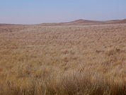
The current mapping on land-cover distribution restricts the Argentinean Pampa grasslands to the Buenos Aires, Córdoba, Santa Fe, Entre Ríos, La Pampa and San Luis provinces. In this study, we reviewed the western distribution of these grasslands by using remote sensing analyses and “in situ” evaluations. We used a 10-years series of MODIS/Terra satellite images as a basis to locate and map the area of study. We also employed a non-supervised classification (ISODATA), complemented with a visual interpretation on Landsat 8 satellite images, to classify pixels into two categories: grassland and shrubland. The accuracy of this classification was 89.1%, verified through an error matrix by using high resolution images from Google Earth. We identified a new area of 3050 km2 of Pampa grasslands that was not considered in previous land-cover vegetation maps. This area, previously categorized as shrublands, is located west of the Salado river, at the south-east of Mendoza and north-center of La Pampa provinces, between 35.362° and 36.257° S, and 66.613° and 67.264° W. Vegetation surveys in specific sites showed that they are typical semiarid Pampa grasslands, dominated by C4 perennial tussocks of Elionurus muticus (28% of area cover). Other important species, with area covers between 1 and 5%, were Hyalis argentea, Sporobolus cryptandrus, Aristida mendocina, Bothriochloa springfieldii and Eragrostis lugens. The inherent low replacement rate that occurs in this semiarid region of Argentina enhances the importance of these grasslands as reservoirs of this fragile ecosystem.
References
Aguilera, MO; DF Steinaker; MR Demaría & AO Ávila. 1998. Estados y transiciones de los pastizales de Sorghastrum pellitum del área medanosa central de San Luis, Argentina. Ecotropicos, 11:107-120.
Anderson, DL; JA Del Águila & AE Bernardón. 1970. Las formaciones vegetales de la provincia de San Luis. Rev. Inv. Agrop. INTA, 7:83-153.
Cabrera, A. 1953. Esquema fitogeográfico de la Rep. Argentina. Rev. Museo La Plata, 8:87-168.
Capitanelli, R & M Zamorano. 1972. Geografía regional de la Provincia de San Luis. Bol. Est. Geog. U. Cuyo, 20:74-77.
Clement, AA & RG Pontius Jr. 2008. Identifying systematic land-cover transitions using remote sensing and GIS: the fate of forests inside and outside protected areas of Southwestern Ghana. Env. Plan. B Plan. Design, 35:280-295.
Congalton, RG. 1991. A review of assessing the accuracy of classifications of remotely sensed data. Rem. Sens. Envir., 37:35-46.
Daubenmire, RF. 1959. A canopy coverage method. North. Science, 33:43-64.
Demaría, MR; I Aguado Suárez & DF Steinaker. 2008. Reemplazo y fragmentación de pastizales pampeanos semiáridos en San Luis, Argentina. Ecol. Austral, 18:55-70.
Frenguelli, J. 1941. Rasgos principales de la fitogeografía Argentina. Rev. Museo La Plata, 3:65-181.
Hansen, M; R DeFries; JRG Townshend & R Sohlberg. 2000. Global land cover classification at 1km resolution using a decision tree classifier. Int. J. Rem. Sensing, 21:1331-1365.
Hay, AM. 1979. Sampling designs to test land-use map accuracy. Phot. Eng. Rem. Sensing, 45:529-533.
Jensen, JR. 1996. Introductory Digital Image Processing: A Remote Sensing Perspective. Prentice Hall, New Jersey.
Lefsky, MA; WB Cohen; GG Parker & DJ Harding. 2002. Lidar remote sensing for ecosystem studies. BioScience, 52:19-30.
León, RJC & DL Anderson. 1983. El límite occidental del pastizal pampeano. Tuexenia, 3:67-83.
Parodi, L. 1945. Las regiones fitogeográficas argentinas y su relación con la industria forestal. Pp. 123-132 en: Verdoorn, F (ed.). Plants and Planta Science in Latin America. Waltham, Mass.
Peña Zubiate, CA; DL Anderson; MA Demmi; JL Saenz & A D’Hiriart. 1998. Carta de suelos y vegetación de la provincia de San Luis. Payne Publishing. San Luis, Argentina.
Soriano, A. 1991. Rio de la Plata Grasslands. Pp. 367–407 en: Coupland, RT (ed.). Ecosystems of the World. Natural Grasslands: Introduction and Western Hemisphere. Elsevier, New York.
Stein, A; FD Meer; Van Der & B Gorte. 1999. Spatial Statistics for Remote Sensing. Kluwer Academic Publishers, Dordrecht.
Treitz, P & P Howarth. 2000. High spatial resolution remote sensing data for forest ecosystem classification – an examination of spatial scale. Rem. Sen. Env., 72:268-289.
Downloads
Published
How to Cite
Issue
Section
License
Copyright (c) 2016 Manuel R. Demaria, Juan P. Martini, Diego F. Steinaker

This work is licensed under a Creative Commons Attribution 3.0 Unported License.
Authors retain their rights as follows: 1) by granting the journal the right to its first publication, and 2) by registering the published article with a Creative Commons Attribution License (CC-BY 4.0), which allows authors and third parties to view and use it as long as they clearly mention its origin (citation or reference, including authorship and first publication in this journal). Authors can make other non-exclusive distribution agreements as long as they clearly indicate their origin and are encouraged to widely share and disseminate the published version of their work.

